

A Tale of Three Cities (well, "Villages" anyway)
Early Canal Fulton
Naturally, the first settlers to come to this quiet
little river valley - in what we now know of as Canal
Fulton - were Native Americans. A unique combination
of factors would for a time make the Ohio wilderness an ideal place
for these early inhabitants to call home.1
One of these factors, the Tuscarawas River, would
continue to be a major contributor to area settlements. The
Tuscarawas begins in northern Stark County (just south
of the St. Lawrence Seaway continental divide) and winds
its way westward and south before opening up into the
larger Muskingum River.2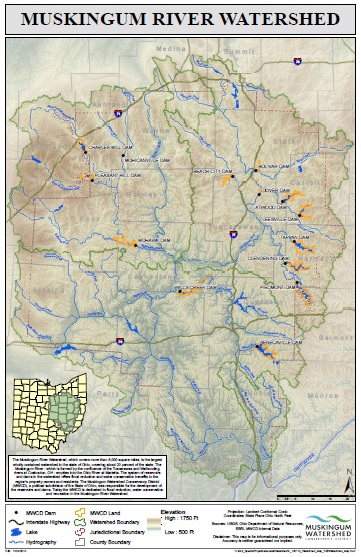 The Muskingum then contributes to the Ohio River
which spills into the Mississippi, bisecting the entire
country. All of these various systems of natural waterways were not
only convenient but essential transportation routes
necessary for the establishment of early settelments.
The Muskingum then contributes to the Ohio River
which spills into the Mississippi, bisecting the entire
country. All of these various systems of natural waterways were not
only convenient but essential transportation routes
necessary for the establishment of early settelments.
Through the past centuries, various Native peoples have inhabited the Tuscarawas River watershed. It is said that the Delaware Indians came to regard this area the best in northeastern Ohio for fishing.3 While each of the Native tribes would be displaced in ensuing years, traces of their culture remain throughout the area today. "Ohio," "erie," "tuscarawas," and many other words have found their way into today's lexicon.4 Continuing to leave their mark, inspiring, harrowing and all other manner of complex stories surround area history leading up to and culminating with the United States victory at the Battle of Fallen Timbers and the subsequent Treaty of Fort Industry.5
As competition for finite resources has ever been a driving force in human history, the leaders of the newly-founded United States of America were eager to see the Ohio Territory settled. So in the year 1800, the lands controlled by the US (which had been limited to the east side of the Tuscarawas River boundary) were surveyed to make way for land speculators and buyers.6 With the signing of the Fort Industry treaty in 1805, Ohio's Native Americans agreed to relinquish their claim to the lands west of the Tuscarawas as well; thus, in 1807, the lands beyond the river were surveyed and also made open for this latest wave of American inhabitants. The frugal and pioneering spirits who resettled our specific portion of this river valley preferred the newly surveyed lots on the western bank - these had been surveyed in smaller, more affordable size lots - whose soil was also regarded as better suited for farming and building when compared to the eastern bank.7 It was very shortly thereafter, in the year 1814, that the village of Milan was established.8
In these early 1800's, many small towns were springing up around Ohio. With names like Rome, Dresden, Berlin, Dublin and Milan it seems clear that while town founders knew the reality of their meager back-country locality, they still recalled the great cities of Europe and perhaps basked in the hopes of such renown for their new home.
Life in early Milan no doubt had its challenges. It was a new village inhabiting an area of country that was regarded as wilderness a mere decade before. It enjoyed neither the industry, economy nor access to transportation afforded by cities along larger bodies of water like the Ohio River. However, this would soon change as legislators in the State Capitol began working out the minutia of Ohio's canal system. Anticipating the economic boom that our neighbors in New York experienced from their Erie Canal, plans for internal improvements began flying all around our infant state,9 and in 1825 the State Legislature passed an act that would enable the construction of our first system of interstate-transportation: the canals! 10
It was at this time, in 1826, that the village of Fulton was drawn up.11 Local innovators were fully expecting commerce and industry to flow forth from the inrushing waters of the Ohio & Erie Canal. The route of the canal through this portion of Stark County was then set to follow the eastern bank of the Tuscarawas, and Fulton was expressly laid out to parallel this major man-made waterway. It was something of a gamble as this portion of canal would not be completed for another year and the first canal boat wouldn't pass through the village until 1828.12 Nevertheless, the expectations and designs of these entrepreneurs were not in vain. Soon the population, commerce and industry brought by the canal would be realized not just here in Stark County but throughout the state and beyond!13
Fultonians, with their immediate access to the canal, had a clear advantage over their neighbors in Milan. However, even communities without direct contact to this new trade route could benefit from the overall prosperity it brought. An example of such affluence was made evident in 1832 when the hamlet of West Fulton was founded. * This newest town afforded further housing and business opportunities to residents - allowing even more folks to reap the bounties of this man-made waterway.14
Certainly all the area townsfolk profited from their connection with this transportation hub, but eventually Fulton's success would consume its smaller neighbors and by 1853 the three villages would merge into one.15
The Canal and Coal Boom (and bust)
In 1814 who could have thought that the modest little farm village of Milan would be enjoying the successes of an important inland port? The Ohio & Erie Canal brought the opportunities for businesses and industry to this once wilderness. These in turn attracted labor, which brought families, which spurred on the development of service industries, cultural pursuits and education. For certain, the Fulton area became a bustling place!16 Indeed, it was out of appreciation for this hustle and bustle that the prefix of "Canal" was added to Fulton.17 Burgeoning agriculture would surround this new port and reportedly, wagons would line up all the way from the Wayne County line (3 miles away) as farmers waited their turn to off-load their produce in the Canal Fulton market.18 Planters, from perhaps as far away as Ashland and Alliance, may have spent hours getting thier grains here to the Canal Fulton market.19 This, in turn, was then shipped to larger markets in Akron, Cleveland and far beyond!20
Our ancestors have long known that moving goods and people by way of water is far more efficient than by land and finally, with these canals this vast and sprawling young nation had the transportation system necessary to support its growing needs.
Because of the system of rivers and canals that crisscrossed the country, rural Ohio farmers could now ship their produce to feed the bustling burgs along the country's eastern and southern coasts. These new market opportunities also allowed for much cheaper transportation of imported necessities and comforts. With many of Canal Fulton's businesses being either middle-men within this shipping chain or providing services to the canaling industry, truly the Ohio & Erie Canal brought prosperity to all.
However, by the 1850's, only a few short decades after "canal fever" had swept the nation, the canals would come into direct competition with another technological and engineering marvel: the steam powered locomotive engine.21 Throughout the state (and indeed the rest of the country) the business of transportation began giving way to this newest form of hydraulic power.*
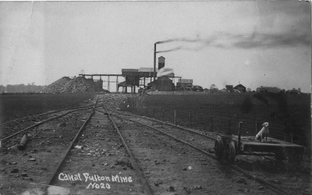
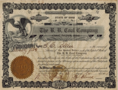
Despite these shifting tides, Canal Fulton would continue reaping the benefits of its geography, not from its water resources but this time from those found in its land. As the spiderweb of train networks continued spreading so also did its need for fuel grow, and to its benefit, this river valley and much of the surrounding countryside would be found rich in coal. More than 20 coal mines would dot this northwestern corner of Lawrence Township and many, many other mines were established throughout neighboring communities.22 The growth of the coal business would stoke the flames of industrial production throughout this area (as indeed the nation). Canal Fulton businesses adapted to these changes and by the 1880's, focus on the canals had given way to the mechanized demands of coal mining and other manufactories. 23
Unfortunately though, this chapter of Canal Fulton history would be relatively short-lived itself as Fultonians came to realize their coal fields were not inexhaustible.24 Both the canal and coal eras entered with a boom; yet, within a few short decades they would exist only as smoldering remnants. While their presence and legacy would remain, through the early 1900's, both industries were all but extinguished.
In the Wake of the Canal Era
While Canal Fulton lay within the network of steel
rails of the locomotive,25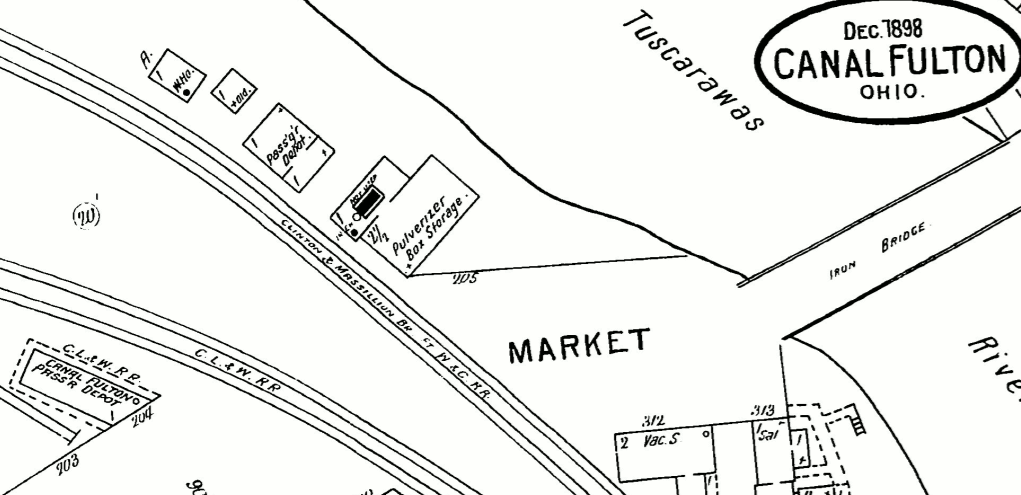 the Iron Horse had found hubs in other area cities
like Akron, Barberton, Massilon and Canton.
With the canals and coal in decline local businesses
found themselves at a new crossroads. However this time, though some industry would
remain in the village, little-old Canal Fulton just
couldn't compete with the opportunities found in its
larger neighbors and through the early 1900's
the town's population would stagnate.26
the Iron Horse had found hubs in other area cities
like Akron, Barberton, Massilon and Canton.
With the canals and coal in decline local businesses
found themselves at a new crossroads. However this time, though some industry would
remain in the village, little-old Canal Fulton just
couldn't compete with the opportunities found in its
larger neighbors and through the early 1900's
the town's population would stagnate.26
Despite all its other ups and downs, farming (that age-old vocation on which Milan's first residents bravely carved out their livelihood) would prove to have been the area's most sustainable industry throughout these several centuries.
Nevertheless, in the mid 1900's, Canal Fulton would once again be caught up in the rising tides of national events. Throughout World War II and in the years following, a new wave of industrialism would bolster the economy throughout these United States. As much of the war-torn world was rebuilding itself, US products would pour off of manufacturing floors in efforts to meet these increasing consumer demands. These post-war boom years would also see advances in automotive technology and increased wages. Such factors afforded many laborers the ability to live even further away from the dirty, noisy factories where they worked. At the end of the day, these newly empowered workers could now leave behind the urban bustle and commotion of the big city and little towns like Canal Fulton would reap the benefits from such suburban sprawl. Indeed, through the latter half of the 1900's, Canal Fulton would become a "bedroom" community for its larger neighbors (which were now an affordably short commute away).27 Throughout the last half of the 20th century, Canal Fulton's population would steadily grow.28
Canal Fulton Today
Thankfully, despite its surge in population and suburban growth,
portions of modern day Canal Fulton still retain much of
its historic character. While some structures have changed,
many still showcase building styles popular more than 100
years ago. Though a mere 100 years is as a drop in
the bucket,*
Canal Fultonians can - and should - be proud
of our historic town. Indeed, such community pride spurred
Village administrators, the Canal Fulton Heritage
Society and other residents to pursue
entry of the town onto the National Register of
Historic Places. In the 1970's (with more
than 90 buildings included inside the district)
downtown Canal Fulton was awarded the honor of being
listed on this historic registry.29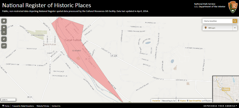 In compliance with this new status, Canal Fulton's Historic
Preservation Commission was established under village
ordinance to retain the historic character of
downtown, so that at least some of the features and feel
of this old town aren't swept away by the fads and trends
of our modern lifestyle. Thus at least a piece of this
more than 200 year old legacy can be preserved for our future
generations.*
In compliance with this new status, Canal Fulton's Historic
Preservation Commission was established under village
ordinance to retain the historic character of
downtown, so that at least some of the features and feel
of this old town aren't swept away by the fads and trends
of our modern lifestyle. Thus at least a piece of this
more than 200 year old legacy can be preserved for our future
generations.*
Through the end of the 1900's, the Village continued growing and at the turn of the new century, Canal Fulton had reached the population level allowing it to incorporate. On March 30, 2001 (with a population of 5,061), Canal Fulton shed the title of "Village" and became a City. 30 Since then, City personnel, the City's HPC, the Heritage Society, and many other concerned civic organizations, business owners and citizens have worked hard to retain the charming historical character that has attracted so many people to this community.* Certainly with a quick glance around town these past years, one can see the care and investment that many residents have been putting into the restoration of the town's old buildings. We certainly can't applaud these efforts enough!

The Blessings of Community
Throughout the centuries, this area has been blessed in a variety of ways. Inhabitants have long enjoyed the natural resources and wildlife in this river valley. The area has also been fortunate to be directly linked to a major interstate transportation route. But one blessing that certainly cannot be overlooked, or underestimated, is its dedicated residents. This community would come together in many ways through the years. The incredible success of the town's Sesquicentennial, as well as subsequent Olde Canal Days Festivals, and many other area events are proof of the community's dedication to celebrating and preserving its history. Many community clubs and organizations, businesses and residents have (through the years) all worked together to foster a spirit of cooperation and common concern for this historic town. May the dedication and accomplishments of all these civic-minded citizens (past and present) continue to be an example to us all!
Residents today continue to enjoy the charming small town nature of this historic community. Canal Fulton has seen a variety of quaint shops and restaurants occupy its historic buildings through these past decades and the same is true today. Stop by and see for yourself that Canal Fulton is "a great place to work, play, live and give."*
Web Page Notes
1. There are many fine works that give an account of Ohio's early history so we don't feel bad herein only making mention of some generalities.
Ohio History Connection. American Indian Sites. https://www.ohiohistory.org/learn/american-indian-relations/american-indian-sites , last accessed January 10, 2018.
Russell H. Booth Jr., The Tuscarawas Valley in Indian Days 1750-1797, Original Journals and Old Maps with Analysis, (Cambridge, OH: Gomber House Press, 1994).
Donald B. Ricky, ed., Encyclopedia of Ohio Indians, Vol. 1, (St. Claire Shores, MI: Somerset Publishers, Inc., 1998).
2. Map of the Muskingum Watershed.
Muskingum Watershed Conservancy District https://www.mwcd.org/upload/images/Watershed_Map_Reduced.pdf
last accessed January 10, 2018)
Waldo M. Streby, Nostalgia, (1978.) 64.
4. "Tuscarawas" originates from a Delaware word meaning something akin to "open mouth."
George W.Knepper, The Official Ohio Lands Book, publication of The Auditor of State, 2002, https://ohioauditor.gov/publications/OhioLandsBook.pdf, page 78, last accessed January 23, 2018.
The Tuscarawas River was regarded by various early inhabitants as simply the upstream portion of the Muskingum River while others regarded them as two different bodies of water. It is logical to see how Native Americans would nonetheless regard the smaller Tuscarawas as the mouth which feeds the larger Muskingum.
Booth, Tuscarawas in Indian Days, xviii.
Thus I have also seen it said that perhaps "mouth of the river" is the more specific origin of the word "Tuscarawas" ~ Website Editor.
5. Whose outcome turned another page in the story of this portion of this Northwest Territory... The Battle of Fallen Timbers (1794) proved to be a last stand for Ohio's Native Americans. Their defeat, marked by the signing of the Greenville Treaty (1795), re-redefined borders. The Fort Industry Treaty (1805) followed up on the Treaty of Greenville, expanding even more of the territory that Ohio's Native Americans would cede to the government of the United States.
Knepper, Ohio Lands, 44.
Robert H. Folger, 'Chapter 18 - Lawrenece Township,' in History of Stark County, With an Outline Sketch of Ohio, ed. William Henry Perrin (Chicago: Baskin and Battey, Historical Publishers, 1881), 452.
L.H. Everts & Co., Combination Atlas Map of Stark County, (Philadelphia, L.W. Everts & Co., 1875), 23 3/4.
Folger, Lawrence Twp., 457.
Lots were opened at public auction on March 23, 1814 on which date 70 of the 79 lots were sold.
"Canal Fulton Indian Territory," The Canal Fulton (Ohio) Canawler Newsletter, 1972, Vol.5, No.2.
1814 Original Plat Map of Milan, Stark County Recorder's Office, reprint, Canal Fulton Heritage Society, Canal Fulton, Ohio: The Canal Era 1814-1913, (Canal Fulton, Ohio: Ye Olde Print Shoppe), 1.
9. Various canals had been constructed throughout the early 1800's, yet these met with only marginal success. However, the Erie Canal opened up all new possibilities for farmers, merchants, travelers and more.
...reference note and more details forth coming...
Terry K. Woods, Ohio's Grand Canal: A Brief History of the Ohio & Erie Canal, (Kent, Ohio: Kent State University Press, 2008), 4f.
The National Road had begun some decades before but it only offered one route, by comparison the Ohio & Erie Canal branched into Pennsylvania twice (the Pennsylvania & Ohio and the Sandy & Beaver) as did the Miami & Erie into Indiana (the Cincinnati & Whitewater and the Wabash & Erie).
Folger, Lawrence Twp., 458.
...additional footnote and reference forth coming...
12. The official opening of the canal from Akron to Massillon took place on Aug 28th, 1828. Celebrations would continue from Akron (which had opened the year before) as the inaugrual boat, the State of Ohio, made her way south - she would pass through Canal Fulton on Aug 25th.
Terry Woods, "The Ohio & Erie Canal in Stark County," Stark County Sampler: A Driving and Walking Tour of Historic Canal Corridor Sites and Structures: Massillon, Canal Fulton, Clinton Area, (Stark Preservation Alliance, 18 August 1996).
Joetta Brownfield, "A Short Chronolgy of Canal Fulton History," The Canawler, 1976, Vol.8, No.2.
13. Indeed, a "canal fever" would take hold in many communities throughout the 24 states of this young nation.
Lynn Metzger and Peg Bobel, eds. Canal Fever: The Ohio & Erie Canal from Waterway to Canalway (Kent, Ohio: Kent State University Press, 2009), passim.
14. West Fulton was founded by Daniel Slanker.
1835 Original Plat Map of West Fulton, Stark County Recorder's Office, reprint, Canal Fulton Heritage Society, Canal Fulton, Ohio: The Canal Era 1814-1913, (Canal Fulton, Ohio: Ye Olde Print Shoppe), 3.
...additional footnote and reference forth coming...
Burton Porter, Old Canal Days, (Columbus, Ohio: Heer Printing Co., 1942), 461.
"This canal town celebrates again," Canton Repository, 15 April 1990.
16. Indeed, the canal would have a big impact throughout the entire state - enlivening its port towns with business.
Woods, Grand Canal, 22f.
17. The exact date doesn't seem to be agreed on by every source we have access to - some indicate that 'Canal' was added in 1830 others in 1840.
"A Brief History," The Canawler.
"Canal Fulton Indian Territory," The Canawler.
Porter, Old Canal Days, 461.
18. "The old timers tell stories of the farmers driving in to Canal Fulton to unload their wheat in such congested numbers that they were frequently forced to pull up and wait in line. It was a very common sight in those days to see wagon upon wagon drawn up one behind the other in lines that extended clear to the edge of Wayne-co several miles long."
Alice Edison, "Picturesque Canal Fulton Once Was One of Ohio's Big Cities," Akron Sunday Times, 2 October 1927, reprint, The Canawler, 1975, Vol.6, No.2.
"A Brief History," The Canawler.
Porter, Old Canal Days, 454.
"Town is Saved From Ruin after Four-Hour Fight," Massillon (Ohio) Evening Independent, 4 August, 1930.
20. We have various accounts of boatmen journeying from here to Cleveland and back.
Porter, Old Canald Days, 247f.
John Robinson, a local merchant, personally traveled back and forth to New York.
...reference forth coming...
21. While steam-powered engines had existed even in the 1830's, when canals were running rampant, it would take several more decades for investors to become confident in this innovation.
...reference forth coming...
The first train to come through Canal Fulton was in ?1965/69? on the Cleveland & Massillon line.
...confirmation reference forth coming...
22. It has been said that some of the first loads of coal to arrive by canal boat to Cleveland came from Bridgeport (near Crystal Springs - between Canal Fulton and Massillon).
Porter, Old Canal Days, 434.
23. Between 1883 and 1893 The Fulton Tool Works, Fulton Machine Company, Fulton Pit Car Works and Fulton Tool and Manufacturing Company would go to work producing various mining tools and implements.
...further footnote and reference forth coming...
24. 1890 seems to have been the peak of local coal mining but by 1905, much of the coal deposits had been spent and by 1940 they were all but exhausted
...further footnote and reference forth coming...
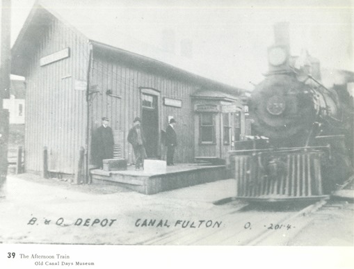
25.
For a time, Canal Fulton had two rail lines each with a stop here. *
The C & M would be the second line (these tracks were torn out
and the Old Muskingum Trail was built atop its rail bed). It
was laid through the village in 1871-72.
Porter, Old Canal Days, 402.
In case you are wondering why you've seen these various lines refered to as other names (e.g. the C.L & W [1898] are the same tracks used by the B & O [1911]) in other photos, maps or documents, these lines were pieces within larger rail networks - whose complex histories are not herein recounted.
Sanborn-Perris Map Company, 1899, sheet#4. Canal Fulton, Stark County, OH; December 1898" [Fire Insurance Map] last accessed November 27, 2011 from the Canal Fulton Public Library's Digital Online Database.
Sanborn Map Company, 1911, sheet#4. Canal Fulton, Stark County, OH; October 1898" [Fire Insurance Map] last accessed November 27, 2011 from the Canal Fulton Public Library's Digital Online Database.
CFHS, The Canal Era 1814-1913, 39. Picture from collection of Clyde Gainey.
26. Generally, Canal Fulton's population in the early 20th century held at about 1,000.
Decennial Census of Population, 1900 to 2000, by Place, https://development.ohio.gov/files/research/plchist.pdf, last accessed 2-7-19.
27. "We sorta turned out to be a bedroom town." ~ Wilbur Bliler, recalled how town industries went out after coal mining had ceased.
"Men have memories of 150 year-old Canal Fulton," Canton Repository, 15 April 1990.
28. In 1950 the population trend started taking an upward swing to about 1,200; 1960 to 1,500 and on up from there.
Decennial Census of Population, 1900 to 2000.
The report on the 1990 Census of Population and Housing for Ohio indicates the following: Canal Fulton's population rose markedly from 1970 to 1990 [1970 = 2,367; 1980 = 3,481; 1990 = 4,157] (as did the rest of Lawrence Township [1970 = 7K; 1980 = 11K; 1990 = 12K]), while Massillon's [1970 = 32K; 1980 = 30K, 1990 = 31K] and Canton's [1970 = 110K; 1980 = 93K; 1990 = 84K] populations both went down. One might further make note that Stark County's total population fluctuations [1970 = 372K; 1980 = 378K; 1990 = 367K] seem to indicate that (taken in its proper perspective) people were flocking to Canal Fulton - with the population increasing to 175% in the span of just 20 years (while populations in Massillon, Canton and Stark County in general went down within this same time span) how else can one describe it!?
The number of Housing Units for each area indicate the same trends, surely making it plain that Canal Fulton was growing by leaps and bounds compared to it's larger urban neighbors.
U.S. Department of Commerce, Economics and Statistics Administration, Bureau of the Census. 1990 Census of Population and Housing, Population and Housing Unit Counts, Ohio. 1990 CPH-2-37. U.S. Government Printing Office, Washington, DC 20402.
29. In reflecting on both the honors and duties of being included on this national list Ann McLaughlin (then President of the Heritage Society) said, "What we now do with this Heritage is up to us! Can we build on what we have been given? Can we use this heritage to tell a unique and important story? Can we make sure the story of Canal Fulton and the Canal is not lost to future generations?"
Ann McLaughlin, "President's Corner: Historic District on National Register", Canal Fulton Heritage Society Newsletter, March 1983, CFHS records.
Map of Historic Places, Screen Shot taken from https://www.nps.gov/maps/full.html?mapId=7ad17cc9-b808-4ff8-a2f9-a99909164466, © OpenStreetMap contributors, https://www.openstreetmap.org/copyright, last accessed January 26, 2019.
...footnote & reference forth coming...